Home > Apps > Travel & Local > mBDL

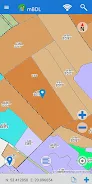
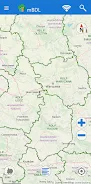
Introducing the mBDL app – your mobile forest data hub! Access detailed forest maps directly on your phone or tablet. This app provides a wide range of thematic BDL maps, including base maps, tree stand maps, ownership information, forest habitat maps, plant community maps, hunting maps, tourism development maps, and fire hazard maps. You can also overlay raster backgrounds such as topographic maps or aerial/satellite orthophotos. Download data for offline use, ensuring convenient access in remote forest districts and national parks, even without internet connectivity.
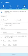
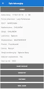
Beyond maps, access comprehensive taxation descriptions for all forest ownership types. This includes detailed species information (trees and shrubs), forest addresses, and key economic indicators. The app also features area and distance measurement tools, GPS tracking, route recording, and navigation capabilities. Export saved waypoints and routes as KML files for easy sharing. Search for forest divisions using forest addresses, cadastral parcels, or coordinates. Consult the included manual to learn more about the app's functionalities. Download the mBDL app now at https://www.bdl.lasy.gov.pl/portal/deklaracja-mbdl
App Features:
- Direct access to forest maps on mobile devices.
- Comprehensive BDL map layers: base maps, tree stands, ownership, habitats, plant communities, hunting areas, tourism, and fire hazards.
- Support for raster backgrounds (topographic, aerial/satellite orthophotos) and external WMS services.
- Offline map access for use in remote areas.
- Online access to detailed forest taxation information, including species details, addresses, and economic data.
- Integrated tools for area/distance measurement, GPS tracking, route recording, and navigation.
Conclusion:
The mBDL app offers unparalleled access to forest data and mapping tools. Its diverse map layers, offline capabilities, and detailed taxation information make it invaluable for forest owners, researchers, and enthusiasts. The integrated measurement, GPS, and navigation tools further enhance its usability. Download the mBDL app today for seamless forest exploration and navigation.
Additional Game Information
Latest Version1.19.1 |
Category |
Requires AndroidAndroid 5.1 or later |
mBDL Screenshots


Top Download
More >


Trending apps
-

- Anycubic
- 4.3 Tools
- Experience the next generation of 3D printing with the Anycubic app! Designed for ease of use and convenience, Anycubic lets you remotely manage your 3D printer via the Workbench feature. Monitor print jobs, fine-tune settings, and receive notifications and reports directly on your phone. Access a
-

- Perhitungan Had Kifayah
- 4.0 Communication
- Perhitungan Had Kifayah: A groundbreaking app revolutionizing zakat eligibility determination. This innovative tool considers socio-economic factors and local contexts to calculate the minimum threshold (Had Kifayah) for qualifying as a zakat recipient (mustahik). The assessment encompasses seven
-

- VPN - Unblock Proxy Hotspot
- 4.5 Tools
- Unlock the internet with VPN - Unblock Proxy Hotspot, the premier Android VPN app for secure and private browsing. This intuitive app establishes a high-speed, encrypted VPN connection on your smartphone or tablet, granting access to your favorite websites and apps regardless of location. Bypass g
-

- EVA AIR
- 4.5 Travel & Local
- Experience effortless travel planning with the EVAAIR app. This convenient and user-friendly app handles everything from flight bookings and changes to trip management, check-in, and mileage tracking. Stay informed with push notifications for updates, discounts, and special offers. EVAAIR streamli
-
- Mp3 Juice
- 4.4 Lifestyle
- Unlock the Power of Music with Mp3 Juice APK: Your Ultimate Android Music Converter Mp3 Juice APK is your gateway to a world of limitless music. This powerful Android app lets you convert and download songs effortlessly, offering a premium experience completely free with its modded version. Enjoy u
-

- Internet Download Manager (IDM)
- 4.5 Tools
- Boost your Android downloads with Internet Download Manager (IDM)! This powerful download manager accelerates download speeds by up to 500% using multi-threading technology. Resume interrupted downloads effortlessly and enjoy seamless support for various file types, including direct downloads and t
Latest APP
-

- misterb&b
- 4.3 Travel & Local
- Step into a welcoming world of accommodations and friendly connections with misterb&b. Explore over one million listings across 200 countries, from cozy apartments to LGBTQ-welcoming hotels and even clothing-optional stays. Whether you're booking a
-

- Shohoz
- 4.3 Travel & Local
- Discover ultimate convenience for your travel bookings with the Shohoz app! As Bangladesh’s top online ticketing platform, the app provides a smooth, user‑friendly experience for Bus, Air, Launch, Event, and Amusement Park tickets. With over 5 milli
-

- MyMRTJ
- 4 Travel & Local
- Discover effortless travel in Jakarta with the MyMRTJ app – your ultimate companion for navigating the city via MRT Jakarta. Streamline your commute with instant ticket purchases, real-time schedules, detailed station guides, loyalty rewards, and on
-

- SeguíTuBus
- 4.3 Travel & Local
- SeguíTuBus is an intuitive and effective mobile application that delivers live updates on bus departures and arrivals at Montevideo's Tres Cruces Terminal. Whether you travel regularly or are simply waiting for your bus, this tool enables you to moni
-
- Yiufi
- 4.4 Travel & Local
- Meet Yiufi, the groundbreaking app transforming how drivers and energy stations connect and work together. We've discovered a powerful opportunity to build a platform that serves both drivers and energy/fuel stations, delivering mutual benefits acros
-

- Haup
- 4 Travel & Local
- Experience the future of mobility in Thailand with the Haup app, your ultimate car-sharing solution. Plan weekend escapes, daily commutes, or spontaneous road trips with ease. Forget cumbersome rental procedures—unlock your car with a single tap on
-

- Főnix Taxi Debrecen
- 4.4 Travel & Local
- Introducing Főnix Taxi Debrecen — the brand-new taxi booking app that’s revolutionizing the way you travel in Debrecen. Download the Főnix Taxi Debrecen app today and discover the fastest, most convenient way to order a taxi at your fingertips. With just a single tap, you can locate and book the nea
-

- Hotel and Guesthouse Finder
- 4.4 Travel & Local
- Easily locate and navigate to hotels and guesthouses with the Hotel and Guesthouse Finder app. Whether you're exploring your local area or traveling internationally, this intuitive app enables you to search for nearby accommodations using either a list or map view. You can also access comprehensive
-

- AZAL - Book Flight Ticket
- 4 Travel & Local
- Elevate your travel experience with the AZAL - Book Flight Ticket App! With an expansive selection of over 50 destinations, booking your next flight has never been more straightforward. The app offers unparalleled convenience, allowing you to pre-select your in-flight meals, check in online, manage